雅思官方白金级合作伙伴
咨询电话:0312-59361112021-07-16 17:18:02 编辑:保定环球教育 浏览:(473次)
保定环球雅思咨询热线:0312-5936111
环球教育保定雅思培训学校提供:2021雅思Task1小作文柱状图范文之村庄变迁!关注环球教育保定分校(bdgedu)微信公众号,获取更多保定雅思资讯。
话题:
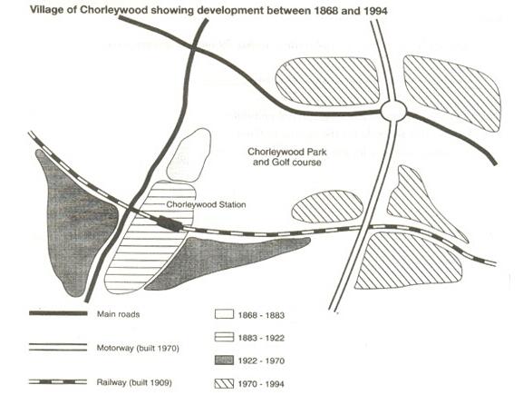
The map shows the village of Chorleywood showing development between 1868 and 1994

范文
The map shows the growth of a village called Chorleywood between 1868 and 1994.
It is clear that the village grew as the transport infrastructure was improved. Four periods of development are shown on the map, and each of the populated areas is near to the main roads, the railway or the motorway.
From 1868 to 1883, Chorleywood covered a small area next to one of the main roads. Chorleywood Park and Golf Course is now located next to this original village area. The village grew along the main road to the south between 1883 and 1922, and in 1909 a railway line was built crossing this area from west to east. Chorleywood station is in this part of the village.
The expansion of Chorleywood continued to the east and west alongside the railway line until 1970. At that time, a motorway was built to the east of the village, and from 1970 to 1994, further development of the village took place around motorway intersections with the railway and one of the main roads.

相关推荐:
咨询热线:18931203815
北京环球天下教育科技有限公司 版权所有 客服信箱:Marketing@gedu.org
投诉电话:010-62125800-2572 Copyright © 1997-2020 Global Education. All rights reserved.